Welcome to Killeavy.com
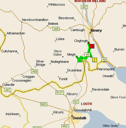
Killeavy is situated in the heart of South Armagh about three miles from Newry. Killeavy consists of an area of 30 square miles ranging from Cloughoge, Killean, Meigh and touching the border at Carrickcarnon.
You can see from the map on the
right the three areas

Meigh which has the green 1 beside it.
Killean which is highlighted by the yellow 2
Cloughoge with the read 3 beside it
From the zoomed map you can also see most of the local villages of South Armagh including Silver Bridge Newtownhamliton , Cullyhanna, Forkhill and WhiteCross. You can also see the three towns Crossmaglen and the newly made city Newry and the Southern Ireland Town Dundalk.
click on the picture to enlarge it .
Places of interest
In Killeavy we have quite a lot of places of interest one of them is the Flagstaff view point .Selive Gullion is also an outstanding place of beauty which overlooks Camlough lake (Below)
Newry Canal
Newry Canal
by Bernadette O'Rourke
It is with great pride and nostalgia that the people of Newry look back on the history of the Newry canal. Built between 1731 and 1742 it brought fame and fortune to the town of Newry. It was built primarily to transport coal from East Tyrone to Dublin and in 1742, "the Cope of Lough Neagh" made this historic journey. But it was not just coal which the port dealt with. Because of its dealing with a great
variety of merchandise, sugar, fruit, flour, oatmeal, linen and timber, Newry soon became the fourth largest trading town in the whole of Ireland. Newry also became Belfast's biggest rival. A direct passenger service to America was established while trade flourished with other countries further a field.
But everything was not quite up to standard. By the end of the 18th century the canal was in a state of disrepair. In 1800 because of the need for larger funds for repairs, control of the waterway was handed from the "local commissioner" to the Director General of inland Navigation. Many suggestions were made and the one which was accepted was the plan to extend the ship canal. It was to be lengthened one and a half miles so that it now ended just north of Narrow Water. The reconstruction was carried out under Sir John Rennie and was completed in April, 1850. After it was finished three 500 ton vessels passed up to the Albert Basin,
in the heart of Newry. But due to many factors traffic began to fall away. In 1829 control of the canal passed to the newly formed Newry Navigation Company. In 1840 trade had increased considerably and continued to expand and in 1846, 120,000 tons were carried. This increase lasted only a few years, the toiling
receipts for 1858 showed that the volume of traffic on the canal had declined. The rapid growth of Belfast as a port and manufacturing centre increased the declining importance of the Newry canal.
In 1901 a committee who called themselves Newry Port and Harbour Trust was
set up. They took it upon themselves to try and improve the condition of the canal. Constant repairs were needed, but it proved more than they could handle. By 1939 traffic had decreased considerably. In 1949 a warrant for the abandonment of the canal as far as the town of Newry was issued and through the town in 1956. The swing bridges at the Dublin Road were removed and a fixed bridge was put in its place at The ship canal from Newry to Lower Fathom which linked the town with the sea was officially closed on the 28th March, 1974. We had the regrettable privilege to record posterity the final passage. The ship was not an Irish ship, it was the Anna Borer from Holland carrying a cargo of crude oil.
No vessel will disturb the peaceful waters where now only anglers fish for pike,
trout and perch. Maybe the canal will once again become famous, this time for its coarse fishing and sailing. It would be a shame and a disgrace if the canal was filled in, as suggested. It can still give pleasure to many people.
One thing is certain, we have seen a glorious yesterday and we look forward to an equally glorious to-morrow


